Jump to content
en.plan.aau.dk

News

Landslides Can Be Predicted With Artificial Intelligence

Published online: 17.01.2024

A group of students in surveying at Aalborg University developed a model that can calculate the risk of landslides. They generated a map of a small area in Denmark. With more computing resources available, a national map of the risk of landslides can be created.

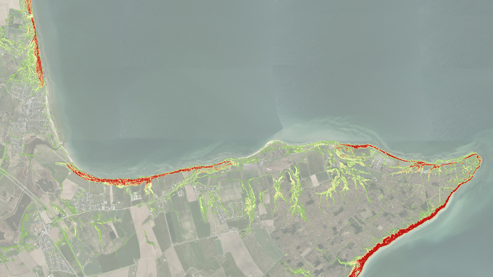
The map shows the risk of landslides in an area around Trelde Klint by Vejle Fjord

By Susanne Togeby, Communication Specialist, AAU Communication and Public Affairs. Translated by LeeAnn Iovanni, AAU Communication and Public Affairs

At the beginning of January 2024, several landslides occurred on Møns Klint where a large section of the point collapsed and slid 200 meters into the sea. According to local media, tourists were nearby who both saw and felt the landslide, but fortunately no one was injured.

In the interest of safety, Møns Klint was closed to the public, but only after the landslides had occurred, which was actually too late. For it is not yet possible to predict when landslides will occur in Denmark.

But in fact, thanks to a group of students in surveying at Aalborg University, it is technically possible to determine the risk of landslides in an area. The four students developed a model that uses artificial intelligence to calculate the probability of landslides.
Landslides in Denmark

The landslide on Møns Klint is the latest example of landslides in Denmark. Another current example is the landslide in Ølst near Randers shortly before Christmas 2023 that triggered a serious risk of many tons of contaminated soil being released into the nearby Alling River and further into Randers Fjord, resulting in an even greater environmental disaster.

The factors that influence the risk of landslides include both climate conditions like cloudbursts and man-made conditions such as when we build motorways or bridges.

It will require far more research resources to calculate the risk of landslides throughout Denmark. But the model has great potential.

Lars Bodum, Associate Professor, Department of Sustainability and Planning, Aalborg University

Map of the risk of Vejle Fjord

For reasons related to resources, the students' project was limited to the area around Vejle Fjord, says Lars Bodum, Associate Professor in the Department of Sustainability and Planning and supervisor on the project:

"Due to capacity issues, the students only calculated the risk for a small area, Vejle Fjord. It will require far more research resources to calculate the risk of landslides throughout Denmark. But the model has great potential – especially if it is expanded with information on, for example, rainfall and human activity in specific areas."

The maps show the risk of landslides calculated using different models in machine learning.
The maps show the risk of landslides calculated using different models in machine learning, which is part of the field of artificial intelligence. The students in surveying evaluated the models for the project.

The computer gets smarter and smarter with data on previous landslides

To create a map of the risk of landslides, the students turned to a branch of artificial intelligence called machine learning. This means that the computer gradually gets smarter based on the data you feed it. The students gained access to a survey of 3200 landslides in Denmark that they loaded into the computer.

When the computer is fed information about certain conditions that were present when the landslides occurred, the computer over time gets better and better at calculating the probability of landslides in similar situations. For example, if you know that a cloudburst triggered a landslide in a certain area, the computer will be able to estimate the probability that it will happen again after a similar cloudburst.

Previous landslides in an area and the probability of landslides in the future
Higher groundwater levels in an area as a result of increased rainfall are an important factor in the number and size of landslides that subsequently occur in the same area.

Lars Bodum, Associate Professor, Department of Sustainability and Planning, Aalborg University

Climate change increases the risk of landslides

Landslides have historically not been perceived as a threat in Denmark like they are in Norway and southern Europe which are much more vulnerable to landslides due to mountains and large rivers.

Nevertheless, the Geological Survey of Denmark and Greenland (GEUS) has mapped as many as 3200 major and minor landslides in Denmark. And the risk of landslides in Denmark will be greater due to climate change with wetter and wilder weather, geologists predict.

"Other studies have shown that higher groundwater levels in an area as a result of increased rainfall are an important factor in the number and size of landslides that subsequently occur in the same area. So, we need to keep an eye on developments, and this requires us to better adapt our models to the reality we live in now to be able to predict the risk of landslides more accurately," says Lars Bodum.

About the project

The mapping of landslide risk was done by four students in surveying at Aalborg University in their eighth semester: Angelina Vyacheslavovna Ageenko, Kevin Lundholm Lyng Lau Seest Nielsen and Lærke Christina Hansen.

Supervisors on the project were Lars Bodum, Associate Professor and Jamal Jokar Arsanjani, Professor, both in the Department of Sustainability and Planning.

The scientific method is described in the International Journal of Geo-Information in the article:  Landslide Susceptibility Mapping Using Machine Learning: A Danish Case Study.

Learn About the Programs in Surveying